Soil degradation has driven to a global increase in inundations
“It is widely believed but not yet sufficiently empirically proven that resilience enhancement is a cost effective and socially equitable way for reducing the flood damage. ” (Schelfaut et al., 2011)
By Natacha Dupertuis
December 11th, 2020
Land desertification and flooding
Each year, 4 out of 149 million km2 of the terrestrial surface becomes desertified or uncultivable [1]. This is mainly due to climate change, but also to deforestation, soil contamination and farming practices not being respectful of the environment. Vegetation disappearing impacts not only soil quality but also the climate (daily temperatures, humidity, strength of the winds) reinforcing the environmental changes [2]. Soil desertification implies waterproofing and therefore an increase in runoff during strong rains. Despite observations of magnified flooding, the hazard is generally not exceptional and the event magnitude is the consequence of improper urban management. Hence, the danger is to impute the floods to climate change and bypass territory planning problems.
Human actions that weaken soil structure
The most common cultural practices that reduce soil quality and thus water storage capacity are chemical weeding, heavy plowing, increase of field size and slash-and-burn farming1. Forests, marshes and meadows, which can contain water, disappear in favor of cultivable fields and buildings. Adding to this, the hydric network is not always studied during land development and the outflows are undersized or suppressed by land leveling, for example. In consequence, water can easily accumulate over the surface and erode the soil importantly. On average, cities suffer more damages linked to unsuitable territory transformations rather than damages linked to water rise emitted upstream [3]. It can also happen that drains are clogged with waste and it leads to flooding. However, the major problem in cities is the streets tarring, which implies water accumulation on the surface and thus inundations. To sum up, the best way to manage the inundations is to try to preserve soil structure, improve the rainwater collection system, conserve a maximum of zones able to accommodate the surplus of water and sediments, and rehabilitate green spaces at the expense of concrete [4].
1 Slash-and-burn farming involves burning vegetation in a field to add organic matter to the soil. It’s used to avoid fallow period.
The ambiguity of dams in West Africa
Dams are another factor that contribute to desertification. Indeed, there are around 150 of them in West Africa [5]. They are responsible for an immense loss of freshwater by evaporation and the absence of flooding in lands, which enables a recharge of water and silts. Every year, Algeria loses 250 millions m3 of water from 39 dams by evaporation [6]. Another effect of dams is the disruption of the equilibrium between the fluvial supply of sediments and coastal erosion, which therefore results in a retreat of the coasts [7].
For more than ten years, floods have been a major issue in West Africa, causing deaths, destroyed houses, health problems and migrations. Simultaneously, more dams have been built, but they obviously cannot protect the populations from flooding. The last dam project is the Kandadji dam in Niger. It should ensure electricity production, lands irrigation, drinking water distribution and control of the Niger river flow [8]. To decide the dismantling of a dam, it is thus necessary to carry out an environmental study and evaluate if the benefits brought by a dam are worth keeping.
Hyogo policy framework and migrations in West Africa
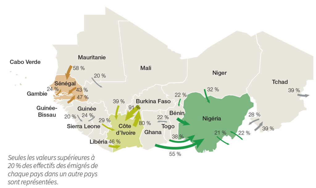
Hyogo policy framework was established to limit natural disasters on a global scale. Although the Executive Council of the African Union is involved in this initiative, it struggles to implement the environmental protection decisions, humanitarian aid and natural disaster management because of the great poverty, increased by years of food shortages, and numerous political conflicts [9]. For these same reasons, West Africa is in the grip of strong migrations. The majority is due to growing food insecurity and exposure to disease; people are forced to move to another part of their country or to other West African countries, as shown in the figure below. Rural areas are economically the most affected and migrations towards cities result in huge uncontrolled and unplanned urban extensions [10].

Climate and floods in Mali
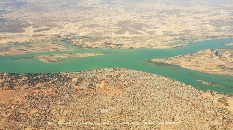
The Malian climate is Sudanese, meaning that the rainy season lasts from June to September and the dry season from December to February. This West African country is located in a carbon sink : it absorbs more greenhouse gases than it emits. An increase of 3 to 6°C is expected in this region for the end of the century [11]. Periods of drought, which are accompanied by strong winds carrying Saharan sand, are consequently lengthened. The Sahara advances 7 km southward each year. The rivers are then silted up, the water points dried up and the water quality threatened. The Niger river loses 30% of its surface per year [12]. In addition, the rainfall has considerably decreased: it is possible to see 40% of the annual rains fall during a week, which implies a significant erosive effect of the rain on the soils. Since 2007, flooding became systematic in Mali and the consequences become more and more important as it is shown by the table below. To deal with these disasters, ECOWAS (Economic Community of West African States) set up an emergency response unit in 2013. However, over time, the damages inflicted by floods lower populations and lands resilience, especially if agriculture has been severely affected in the past. What is needed and what is significantly lacking in Mali, are effective prevention strategies, flood warnings and plans to increase people’s resilience.

References
[1] Scientific service of the European Commission
[2] Bolakonga, I. (2005). Analyse des pluies extrêmes et impacts potentiels sur l’érosion des sols en région sahélienne, cas de quelques localités au Niger et au Mali. Mémoire de DES, inédit, Université de Liège.
[3] Auzet, A.-V., Guerrini, M.-C., & Muxart, T. (1992). L’agriculture et l’érosion des sols : Importance en France de l’érosion liée aux pratiques agricoles. Économie rurale, 105‑110.
[4] Montroi J.-P. (2012, 29-30.03). Rôle des sols sur la genèse des inondations. Symposium européen – Problèmes actuels de la protection contre les inondations, 32 avenue Henri Varagnat 93143 Bondy, France.
[5] Skinner, J., & Koundouno, J. (2013). Haring the benefits of large dams in West Africa. Nature & Faune, 27(1), 26‑29.
[6] Remini, B. (2010). La problématique de l’eau en Algérie du nord. In LARHYSS Journal P-ISSN 1112-3680/E-ISSN 2521-9782, (8).
[7] Jean-Luc Loizeau, professor in Limnology and environmental geology at the University of Geneva. (2020).
[8] https://fr.wikipedia.org/wiki/Barrage_de_Kandadji
[9] Kabau, T. (2012). The responsibility to protect and the role of regional organizations : An appraisal of the African Union’s interventions. Goettingen Journal of International Law, 4, 49‑92.
[10] Gemenne, F., Blocher, J., De Longueville, F., Vigil Diaz Telenti, S., Zickgraf, C., Gharbaoui, D., & Ozer, P. (2017). Changement climatique, catastrophes naturelles et déplacements de populations en Afrique de l’Ouest. Geo-Eco-Trop, 41(3), 317‑337.
[11] IPCC. (2014). Climate Change 2014 : Impacts, adaptation, and vulnerability. Part A: Global and sectoral aspects. Contribution of Working Group II to the Fifth Assessment Report of the Intergovernmental Panel on Climate Change. Cambridge University Press, Cambridge, United Kingdom and New York, NY, USA.
[12] Konaré, S. (2016, novembre 1). Les effets des changements climatiques au Mali. jstm.org. https://www.jstm.org/les-effets-des-changements-climatiques-au-mali/


