Randa rockfall
Introduction
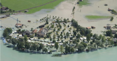
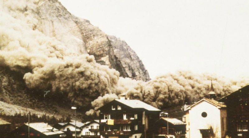
In Switzerland, one region is particularly well known for its frequent rockfalls: The Valais region. With its’s steep topography due to old glaciers eroding during the past Ice ages. The most well-known and massive recent rockfall events happened in 1991 near Randa in the Zermatt Valley. This valley is one of the most frequented by tourists to get to and from the Zermatt resort. Over 20 million cubic meters of rock came crashing into the valley below on 18th of April and a secondary retrogressive rockslide of around 7 million cubic meters followed on the 9th of May. The second event was forecast by field surveys and the valley was evacuated. The massive rockfall did not cause any casualties except for a few horses, sheep and cows. It also buried the train line connecting Zermatt to the Rhone Valley and the main road. The Vispa river was dammed, which resulted in water accumulation upstream from the event. Even though the swiss army managed to drill a 20 meter deep channel through the debris to enable water to flow through, more than 30 houses were flooded during storms in July and August. This prevented an important release of water if fluid pressure accumulating behind the dam got too high and caused failure of the latter. This would have implicated the destruction or flooding of most downstream villages. To this day, the rockfall deposits have not been removed and a new road and train line were put down after the event on the other side of the valley bottom. There have since been small rockfall events since and rock movements of up to 1,5 cm/year, meaning the slope is metastable, with risks of other events happening in the future.
Geological setting and events leading up to the rockfall
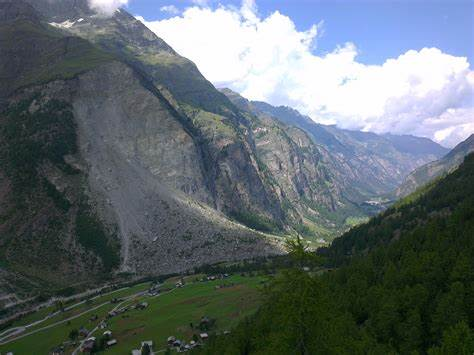
Before the event, structural, hydrological and mechanical conditions ultimately caused these enormous blocks to become unstable. Some of these factors are the steepness of the topography due to the glacier Bis erosion, the presence of a large basal fault which physically separated a huge block from the rest of the mountain, or the crystallization of clay minerals in the fault reducing the mechanical resistance to sliding. The rock units were mostly made up of orthogneisses, overlain by more fractured paragneisses, which are types of metamorphic rocks which are quite competent. The region was freed from glacier support after the last big Ice Age around 15’000 years ago. During glacial and post-glacial times, seismic activity and weathering in the fracture system due to meteoric water infiltration (snowmelt, precipitations) contributed to weaken the rocks mechanically (easier sliding of the surfaces). Furthermore, mechanical crushing due to movement of blocks relative to each other and fluid circulation in the fault enabled weathering of fine crushed material into clay minerals. The formation of clay minerals played two main roles: it facilitated the sliding between blocks and acted as a seal which reduced the permeability of the formation and made it possible for water to accumulate in the fracture system, which was originally open and enabled water to flow out. The accumulation of water led to increasing water pressure provoked hydraulic fracturing on the edges of the key block. The acceleration of the mechanical weakening was observed during the 20 years before the event with increasing rockfall activity and water release, proving to be a precursor to the enormous event in 1991.


Figure a. picture of the intact rockface before the event including the basal fault, the water infiltration zone and the scarps from the two events. Figure b. Structural cross-section into the side of the mountain showing the two rockfall volumes and corresponding units. (Source: quanterra.ch)
The rockfall events
The trigger for the primary event was heavy snow melt and accumulation, inducing failure of the key block which in turn destabilized other blocks. The first event lasted a couple of hours and destabilized the basal part of the mountainside (figure b, blue), so the second event was predictable; the decompressed and highly fractured overlying rocks lacking the support of the key block, it provoked a large rockslide event through which the slope was re-stabilized. It is thought that the main reasons the event involved such important volumes are 1) The strength of the formation, maintaining structure and failing massively when the time came 2) The precipitation of clay minerals in the fault, lowering the mechanical resistance and enabling water accumulation.
References
Articles
- Sartori, M., Baillifard, F., Jaboyedoff, M., Rouiller, J.-D.: Kinematics of the 1991 Randa rockslides (Valais, Switzerland). Natural Hazards and Earth System Science. 3, 423–433 (2003)
- Jaboyedoff, M., Baillifard, F., Bardou, E., Girod, F.: The effect of weathering on Alpine rock instability. Quarterly Journal of Engineering Geology and Hydrogeology. 37, 95–103 (2004). https://doi.org/10.1144/1470-9236/03-046
Websites
- quanterra.ch
Featured image
- planat.ch