Preventing forest fires in Switzerland
Communication
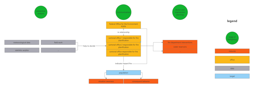
Communication to the population is essential, without it all the measures would be useless. The Swiss system to avoid forestfires is based first and foremost on prevention. As such, each canton presents to the public an indicator expressed on a scale of 1 to 5 that corresponds to the fire danger (1 being low, 5 being very high) on its surface. Thanks to this, the public knows the behaviour to adopt, the risk involved and why certain measures are taken. The Federal Office for the Environment (FOEN) is a federal body for synthesis and coordination between the different cantons for prevention. In addition, it also serves as an synthetic plateform for the public. By consolidating and making the information provided by the cantons available, it extends the scope of information. The cantons are competent to take measures and are responsible for intervention in the event of fire. It is therefore the cantons who make the assessments and estimate the risks encountered locally. However, the cantons are also required to cooperate with the FOEN to ensure that the information is up-to-date and continuously available.
Prevention
An archive on forest fires dating back to 1879 already exists for Southern Switzerland (Ticino and Graubünden) . In 1930, a system for the census of forest fires was developed [1]. This was further developed until 2008 through the establishment of the Swiss Federal Institute for Forest, Snow and Landscape Research (WSL). Thanks to this database called Swissfire, it is therefore possible to have an optimal prevention tool. As all the characteristics of all fires are recorded, it is possible to extract common factors and adapt firefighting strategies [3].
Prevention takes place at several levels. For example, at the cantonal level, danger indicators are not calculated in the same way in two neighbouring cantons such as Ticino and Valais. In the former, the cause of the fires is mainly lightning, while it is more frenquently fires of anthropic origin in the latter. A third level, this time regional, attributes the territorial distribution to the different fire brigades. The creation of open water points also helps the reaction in case of fire [4].
It is this hierarchical and anticipated application that underlines the fact that in 2018 there has been no serious injuries or significant damage [2].
References
[1] Jud, B. A., & Frank, C. (1996). Ein Informationssystem für Waldbrände auf der schweizerischen Alpensüdseite. Schweizerische Zeitschrift für Forstwesen, 147(12), 961-969.
[2] OFEV. « Annuaire La forêt et le bois 2019 ». Office fédéral de l’environnement (OFEV, État de l’environnement, 1914 (2019): 107.
[3] Pezzatti, G. B., Reinhard, M., & Conedera, M. (2010). Swissfire: die neue schweizerische Waldbranddatenbank. Schweizerische Zeitschrift für Forstwesen, 161(11), 465-469. https://doi.org/10.3188/szf.2010.0465
[4] Wohlgemuth, Thomas, Alban Brigger, Philipp Gerold, Lucinda Laranjeiro, Marco Moretti, Barbara Moser, Martine Rebetez, et al. « Vivre avec les incendies de forêt ». Not. prat., 2010, 16.
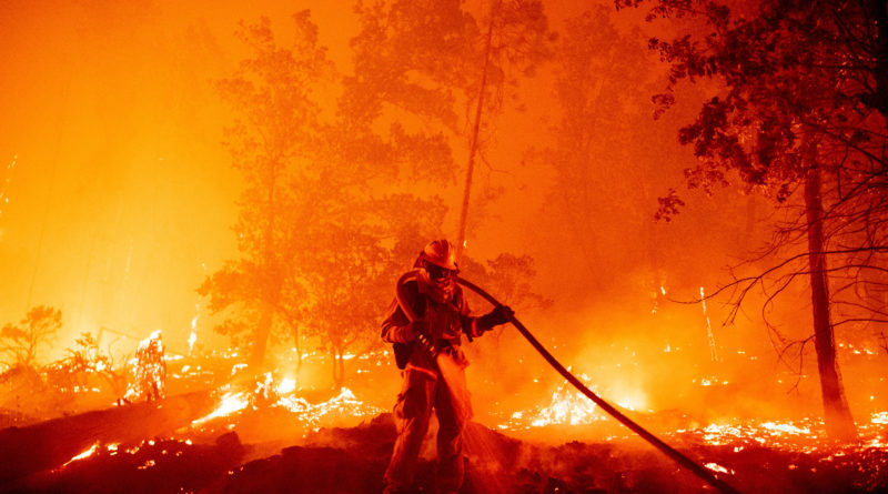
Featured image of the article : Photo by JOSH EDELSON / AFP. Title: A firefighter douses flames as they push towards homes during the Creek fire in the Cascadel Woods area of unincorporated Madera County, California on September 7, 2020.