The increase of geological risks in the Alps
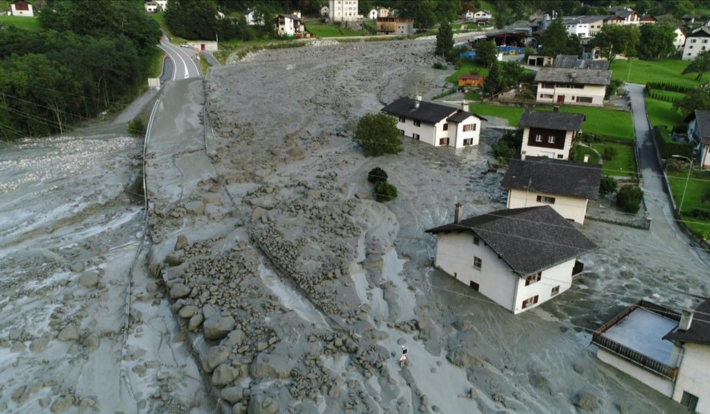
The image of a landslide from the Aletsch region, a village which was evacuated in August 2017, is emblematic of the complicated scientific and human consequences of climate change. In particular, this landslide led to an increase in the designation of restricted building zones. The increase of these designated zones is having a serious impact on the population of Switzerland and is a topic that needs to be continually addressed at the level of science and public policy.
There is a growing concern about the increase of potential hazards due to gravity-related risks in the Alps. Scientists have suggested that there is a direct link between the increase in the frequency of these events and global warming. But is that really the case?

How permafrost works
At high altitudes and latitudes, a percentage of the ground remains completely frozen year-round. If the soil or ground temperature remains at 0°C or less during at least one year it is called permafrost. Based on scientific modelling studies, 5% of the total surface of Switzerland is permafrost. A website of the Helvetian confederation shows these modelled permafrost zones.
Permafrost is made up of a combination of soil, rocks, or sand that are held together by ice. Permafrost is therefore a crucial element in maintaining stable slopes where it currently exists in the Alps.
The steady increase of global temperature, and especially the phenomenon of more and more frequent heatwaves, is decreasing the stability of the permafrost, which is leading to increased occurrences of rockfalls and landslides.
The melting permafrost is not the only a trigger of landslides and rockfalls. Heavy precipitations and especially the rising average rain/snow limit is amplifying the amount of water available to trigger landslides.
As global temperature continues to rise, these phenomena will become more frequent. In addition to this, the contrast between seasonal temperature, in particular a steep increase of heat after winter could lead to an amplification of permafrost melt at high altitude and could further contribute to the destabilization of mountain slopes.
In 2003, for example, the abnormally high temperatures during the heat waves in the Alps led to an increase in the frequency of rockfalls (see picture below). The succession of a hot winter (in terms of the subsoil temperature), and the summer heat waves, had a notably negative impact on the permafrost coverage [1].

“Over the next decades, this [the progressive melt of the permafrost] could result in an increase in landslides, rockfalls and debris flows that could endanger homes, transport infrastructure, gas pipes and power lines in the Alpine massif “
Office fédéral de l’environnement (OFEV), 2018
Survey
This situation is well known among geologists and many surveys have been made in the Alps. In the attempt to study, and at the same time, to monitor these risk-prone areas, several types of measuring instruments are commonly placed, like radar and infrared cameras (see picture below).
Despite the fact that we can measure the average displacement of the rock faces, it is still difficult to predict precisely when a landslide will occur. To maximize the efficiency of an evacuation, an alarm system can be installed to engage when rockfall is detected.

Helvetian confederation is also well aware of this problem and, in 2000, created a national research association to study the evolution of the permafrost, PERMOS (PERmafrost Monitoring Switzerland).
This coordinated observation network measures, archives and interprets permafrost temperatures and the related parameters. With this data, they can model the evolution of the permafrost, which is vital for long term planning.
Consequences
The implication that global warming increases the potential of geological risks in the Alps is undebated. But what does this mean for the population? What are the actual consequences and the repercussions over the long term?
Increased construction within zones of known risk will be contradictory with known science and will have to be addressed at the level of local and national policy. In 2005, an official document has redefined the relation between land use planning and natural hazards. Land-use planning is now directly dependent on the designation of land in terms of known hazards. [3]
Risks are described by this chart, which assigns each zone a color related to the degree of risk (see picture below). The degree, assigned by scientists and based on multiple surveys, is defined by two factors: 1) the intensity of a hazard and 2) the probability of occurrence.

The recommendations for the land use planning document of 2005 describes the legislation of the building permits in Switzerland. It says that the areas with a high potential risk (in red), are unbuildable. Additionally, the document also forbids reconstruction except for special cases.
This policy would create many complications for the people who live in designated risk zones. For example, were a house to be destroyed, would the owners be required to move?
The expansion of designated high-risk zones is related to the well-documented increase of geological risks and to climate change. Will climate change therefore create an increase of human displacement?
In fact, risk reducing measures can be taken. For example, an event like floods, which would be more frequent in the future, can be controlled by installing dykes or walls and therefore reduce the intensity of the hazard. But what would happen if these measures are inefficient, in the case of bigger events like landslides. The landslide that occurred in the village of Bondo in 2017 (first picture) damaged 99 houses with a third of them being destroyed. So, the question is what would have happened to the inhabitants if the entire region of Bondo was in a high risk zone?
References
- [1] « 3.6 Canicule estivale et éboulements superficiels | Géomorphologie de la montagne froide ». Consulté le 8 décembre 2020. https://geomorphologie-montagne.ch/3-6-canicule-estivale-et-eboulements-superficiels/.
- [2] OFEV, Office fédéral de l’environnement. « Carte de l’extension potentielle du pergélisol en Suisse ». Consulté le 8 décembre 2020. https://www.bafu.admin.ch/bafu/fr/home/themen/thema-naturgefahren/naturgefahren–fachinformationen/naturgefahrensituation-und-raumnutzung/gefahrengrundlagen/hinweiskarte-der-permafrostverbreitung-in-der-schweiz.html.
- [3] OFEV, Office fédéral de l’environnement. « Dangers naturels et changements climatiques ». Consulté le 8 décembre 2020. https://www.bafu.admin.ch/bafu/fr/home/themen/thema-naturgefahren/naturgefahren–fachinformationen/gefahrenprozesse/naturgefahren-und-klimawandel.html.
- [4] Sports+, DH Les. « Glissement de terrain dans les Alpes en Suisse: 6 personnes retrouvées en Italie (PHOTOS et VIDEO) ». DH Les Sports +, 24 août 2017. https://www.dhnet.be/actu/faits/glissement-de-terrain-dans-les-alpes-en-suisse-6-personnes-retrouvees-en-italie-photos-et-video-599ef90ccd706e263f9266ed.
- [5] Libre.be, La. « Glissement de terrain dans les Alpes en Suisse: 8 randonneurs sont toujours portés disparus (PHOTOS et VIDEO) ». LaLibre.be, 24 août 2017. https://www.lalibre.be/international/glissement-de-terrain-dans-les-alpes-en-suisse-8-randonneurs-sont-toujours-portes-disparus-photos-et-video-599eea25cd706e263f925456.
- [6] swissinfo.ch, Traduit de l’anglais par Samuel Jaberg. « La montagne a bougé de 10 centimètres par an avant de s’effondrer ». SWI swissinfo.ch. Consulté le 8 décembre 2020. https://www.swissinfo.ch/fre/drame-de-bondo_la-montagne-a-boug%C3%A9-de-10-centim%C3%A8tres-par-an-avant-de-s-effondrer/43469954.
- [7] OFEV, Office fédéral de l’environnement. « Observation du pergélisol ». Consulté le 8 décembre 2020. https://www.bafu.admin.ch/bafu/fr/home/themen/thema-naturgefahren/naturgefahren–daten–indikatoren-und-karten/naturgefahren–monitoringprogramme/permafrostmonitoring.html.
- [8] « Pergélisol ». Consulté le 8 décembre 2020. https://sciencesnaturelles.ch/fr/id/MR7vG.
- [9] « Plate-forme nationale « Dangers naturels » PLANAT– plate-forme d’information pour gérer les dangers naturels en Suisse [Glissement de terrain] ». Consulté le 8 décembre 2020. http://www.planat.ch/fr/bon-a-savoir/glissement-et-chute-de-pierres/glissement-de-terrain/.
- [10] « SUISSE. Glissement de terrain : le réchauffement climatique à l’origine de l’effondrement ». Consulté le 8 décembre 2020. https://www.ledauphine.com/faits-divers/2017/08/24/le-rechauffement-climatique-a-l-origine-de-l-effondrement-d-une-montagne.
- [11] rts.ch. « Un nouvel éboulement déferle sur le village de Bondo dans les Grisons ». InfoSport, 25 août 2017. https://www.rts.ch/info/regions/autres-cantons/8867441-un-nouvel-eboulement-deferle-sur-le-village-de-bondo-dans-les-grisons.html.


